CBS News Live
CBS News Bay Area: Local News, Weather & More
Watch CBS News
Breaking Local News, First Alert Weather & Community Journalism


Highway 1 in the Santa Cruz area has been shut down due to a deadly crash Saturday afternoon, the California Highway Patrol said.

The visas issued to four people at UC Berkeley were revoked by the federal government this week, a campus spokesperson said.

The stock for RH, a home-furnishings company, tanked more than 40 percent. But RH isn't the only retailer that was hit. GAP and Williams Sonoma also saw their stock plunge.

San Francisco Mayor Daniel Lurie unveiled a new upzoning plan that would allow larger, denser development across swaths of the city in an effort to close the affordable housing gap.

More than 1,200 "Hands Off!" demonstrations were planned by more than 150 groups.
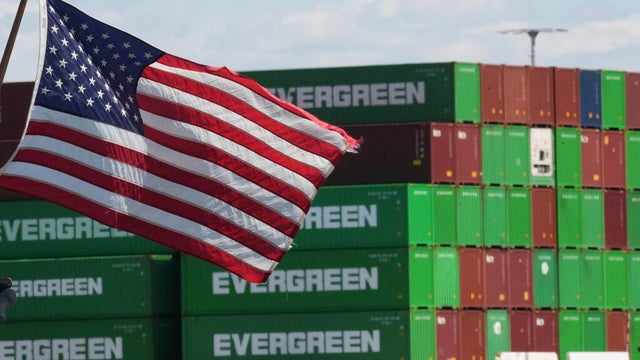
Countries targeted by President Trump for higher so-called reciprocal tariffs are due to go into effect on Wednesday.

It's considered the largest free jazz festival on the West Coast, but this year, the Fillmore may be filled with silence.

California Gov. Gavin Newsom sent a message directed at world leaders on Friday in an attempt to blunt the retaliatory tariffs expected after the Trump administration's "Liberation Day" plans.

Three correctional officers were injured in an attack by an inmate at a prison in Vacaville, authorities said.
The visas issued to four people at UC Berkeley were revoked by the federal government this week, a campus spokesperson said.
The stock for RH, a home-furnishings company, tanked more than 40 percent. But RH isn't the only retailer that was hit. GAP and Williams Sonoma also saw their stock plunge.
San Francisco Mayor Daniel Lurie unveiled a new upzoning plan that would allow larger, denser development across swaths of the city in an effort to close the affordable housing gap.
More than 1,200 "Hands Off!" demonstrations were planned by more than 150 groups.
Countries targeted by President Trump for higher so-called reciprocal tariffs are due to go into effect on Wednesday.

Stephen Curry scored 36 points and the Golden State Warriors beat the Denver Nuggets 118-104 on Friday night for their fifth straight win.

As the ongoing debate over transgender students competing in female sports intensifies in California, in Oakland on Friday, a group of parents called for the California Interscholastic Federation to change its policy.

Willy Adames hit a winning two-run single with two outs in the 11th inning, sending the San Francisco Giants over the Seattle Mariners 10-9 Friday in their home opener to extend their winning streak to five.

The Colorado Rockies lost to the Athletics in their home opener at Coors Field. It was the third coldest home opener in Rockies history.

The Golden State Valkyries on Friday confirmed San Francisco's new WNBA franchise will have CBS Bay Area as the team's official media partner for its inaugural season.

With thousands of plant and animal species, including dozens found nowhere else on Earth, Catalina is a world-class diving destination. Yet scientists warn this underwater paradise faces a growing threat.

At the edge of the Arctic in northern Canada, the annual migration of polar bears draws tourists, photographers, and scientists like Geoff York.

Plastic waste is a huge problem, with bags and packaging a major culprit. A Bay Area startup has figured out a way to replace these plastics, with a plant that grows abundantly off the coast.

Petaluma's experiment with reusable cups last fall was a resounding success according to a newly released report on the project.

The widespread destruction of old growth trees for ranching and farming is making it harder to get the wood traditionally used to make guitars, including mahogany and Brazilian rosewood.

In San Francisco's Dolores Heights, an unusual design and branding studio is the home of two creative artists who earned a Grammy nomination for their groundbreaking album artwork.

President-elect Donald Trump promises to "unleash American energy" by maximizing U.S. oil and gas production. The directive comes at a time when the planet continues to warm, largely due to the burning of fossil fuels, experts say.

When it came to protecting Mother Earth, in many respects, the late President Jimmy Carter was way ahead of his time.

Climate change is triggering more frequent and intense storms as well as flooding. Now a real-life buried treasure – known as a Debris Separating Baffle Box - is seeking to trap the trash before it pollutes critical Bay Area waters.

Here's a look at the weather forecast.

with Zoe Mintz.

The Bay Area enjoyed sunny, clear skies and mild temperatures Friday ahead of a weekend warm-up. Paul Heggen has the forecast.

On Friday, expect clear skies and mild temperatures. For Giants fans heading to Opening Day at Oracle Park, expect highs in the 60s. Jessica Burch has the forecast.

As more people in California lose private insurance, the state's FAIR plan is filling up with homes in places the industry itself has classified as low-risk for wildfire.

The public is on the hook for the FAIR Plan's debt, but we don't have access to the FAIR Plan financials. Should that be legal? California's Insurance Commissioner says, "No." Now he's committing to fix it following a CBS News California Investigation. WATCH THE FULL INVESTIGATION HERE: California FAIR Plan secrets: Why the state's insurer of last resort is so secretive CONTINUING COVERAGE: Investigating California's Insurance Crisis

Once thought of as a small, rarely-used backstop, the FAIR Plan is now one of the largest insurers in the state, and people without FAIR Plan insurance are the ones on the hook for the FAIR Plan's debt. Yet the FAIR Plan is still cloaked in secrecy.
Here's a look at the weather forecast.

Here are the latest headlines.

Bay Area companies are wondering how they will survive the tariffs. Da Lin explains.

As the "Hands Off!" demonstrations took place across the country, here's why people in the Bay Area say they participated.
with Zoe Mintz.

CBS News Bay Area anchor Elizabeth Cook talks with USF professor of law and migration studies Bill Ong Hing about the positions of the Trump and Harris campaigns when it comes to immigration reform and the situation at the border

CBS News Bay Area anchor Elizabeth Cook asks UC Berkeley Haas School of Business professor Olaf Groth, PhD, about how AI could play a role in potential election interference

CBS News Bay Area anchor Anne Makovec asks UCSF infectious disease specialist Dr. Monica Gandhi if Covid is any more serious than a cold these days, the latest on long Covid, and if the bird flu poses any threat of becoming the next pandemic

The race for the White House is flooding our feeds. CBS News Bay Area anchor Anne Makovec asks Dr. Nolan Higdon with CSU East Bay about the impact of influencers in the presidential race, and if they can really tip the scales in battleground states

CBS News Bay Area anchor Anne Makovec hears from Niku Sedarat from San Jose, an incoming Stanford student and member of DoSomething.Org, about an initiative that allows students to share ideas about addressing mental health in their communities. Anne also asks Dr. Nicole Stelter from Blue Shield of California how parents can provide support for their children

CBS News Bay Area anchor Elizabeth Cook has been reporting extensively on the rise in lung cancer cases among non-smoking Asian American women. Now, Liz talks to a Bay Area mother whose trip to Kaiser Permanente Oakland Medical Center after a car crash may have saved her life. Liz also talks to Dr. Jeffrey Velotta, who performed the surgery, about the rise in lung cancer cases in Asian American women and what may be causing them

CBS News Bay Area anchor Elizabeth Cook talks to Coalition on Homelessness Executive Director Jennifer Friedenbach and Senior Vice President of Public Policy for the Bay Area Council Adrian Covert to hear both sides of the debate over Gov. Newsom's executive order to clear homeless encampments

Vice President Kamala Harris has announced her bid for the White House and has appeared to fend off any challengers for the Democratic nomination. CBS News Bay Area anchor Elizabeth Cook asks UC Berkeley Haas School of Business professor Olaf Groth, PhD, which candidate will get support from Silicon Valley

Andrea Nakano and Brian Hackney spoke to San Jose State senior lecturer Donna Crane and Sonoma State professor David McCuan about the stunning developments in the presidential race Sunday. (7-21-24)
The stock for RH, a home-furnishings company, tanked more than 40 percent. But RH isn't the only retailer that was hit. GAP and Williams Sonoma also saw their stock plunge.
San Francisco Mayor Daniel Lurie unveiled a new upzoning plan that would allow larger, denser development across swaths of the city in an effort to close the affordable housing gap.
It's considered the largest free jazz festival on the West Coast, but this year, the Fillmore may be filled with silence.

While all eyes were on the San Francisco Giants home opener Friday, off the field, the team has made headlines for its real estate ventures, particularly in the Mission Rock area near Oracle Park.
Willy Adames hit a winning two-run single with two outs in the 11th inning, sending the San Francisco Giants over the Seattle Mariners 10-9 Friday in their home opener to extend their winning streak to five.
The visas issued to four people at UC Berkeley were revoked by the federal government this week, a campus spokesperson said.
As the ongoing debate over transgender students competing in female sports intensifies in California, in Oakland on Friday, a group of parents called for the California Interscholastic Federation to change its policy.

Bay Area thrash-metal guitar hero Gary Holt recently talked to CBS News Bay Area about his new memoir, upcoming plans for his band Exodus and returning to the stage with Slayer.

One man has died and another man was wounded following a shooting in West Oakland early Friday morning, police said.

An investigation is underway following a police shooting that stemmed from a traffic stop in Concord late Thursday night.

Fire personnel in San Jose were unable to find any victims at the scene a partial roof collapse Friday afternoon at a South Bay recycling facility.

Eight suspected gang members from Monterey and Sacramento counties have been arrested in connection with a deadly shooting in San Jose earlier this year, police said.

Authorities in Santa Cruz County have identified a man who was a person of interest in a 1976 homicide near Aptos Village Park as the suspect in that murder.

International students who recently visited Stanford University are breathing a sigh of relief. After their passports and other important belongings were stolen, a group of Good Samaritans in San Francisco found the items and returned them to their rightful owners.

Police in Gilroy announced the arrests of five people following a fight that injured three men in the city's downtown earlier this week.

A rash of robberies targeting camera shops in the Bay Area continues with more stores getting hit, including two stores in the North Bay.

A forklift operator at a wine storage facility in Windsor was crushed to death by a pallet of wine on Thursday afternoon, authorities said.

After nearly 25 years, the remains of two Jane and John Does found in Sonoma County have been identified through the help of DNA technology, authorities said.

With President Trump announcing sweeping tariffs on imports, businesses that rely on goods from out of the country are worried.

San Francisco Bay has seen a recent influx of gray whales since late March, including one that washed ashore dead on a Marin County beach over the weekend.
The visas issued to four people at UC Berkeley were revoked by the federal government this week, a campus spokesperson said.

A friend group of 20-something tech workers living in San Francisco has made creative event planning a hallmark of their social circle.

People living in two homeless shelters on Wood Street in Oakland will have a little more time with a roof over their heads.

Some business owners who lease property from the California Department of Transportation have been served eviction notices.

San Francisco philanthropist Roselyne "Cissie" Swig, at 94 years old, remains a prominent figure in the city's social justice and arts communities.
Highway 1 in the Santa Cruz area has been shut down due to a deadly crash Saturday afternoon, the California Highway Patrol said.
The visas issued to four people at UC Berkeley were revoked by the federal government this week, a campus spokesperson said.
The stock for RH, a home-furnishings company, tanked more than 40 percent. But RH isn't the only retailer that was hit. GAP and Williams Sonoma also saw their stock plunge.
San Francisco Mayor Daniel Lurie unveiled a new upzoning plan that would allow larger, denser development across swaths of the city in an effort to close the affordable housing gap.
More than 1,200 "Hands Off!" demonstrations were planned by more than 150 groups.

A fire involving a portable air compressor at the Martinez Refining Company on Wednesday night left one person injured, according to officials.

Tony's Chocolonely is recalling some products after consumers reported finding "small stones" in the chocolate bars.

A University of California, Berkeley student has created an artificial intelligence startup to help people detect strokes and other medical emergencies and will be taking part in an innovation competition on Wednesday, the university said.

As mass layoffs commenced nationwide for Department of Health and Human Services workers, one employee seen leaving the Nancy Pelosi Federal Building in San Francisco Tuesday morning said she was "devastated" and "heartbroken."

Workers at University of California campuses in the Bay Area joined thousands of employees statewide Tuesday in a one-day strike, claiming unfair labor practices.
Three correctional officers were injured in an attack by an inmate at a prison in Vacaville, authorities said.
Eight suspected gang members from Monterey and Sacramento counties have been arrested in connection with a deadly shooting in San Jose earlier this year, police said.
One man has died and another man was wounded following a shooting in West Oakland early Friday morning, police said.
Authorities in Santa Cruz County have identified a man who was a person of interest in a 1976 homicide near Aptos Village Park as the suspect in that murder.
International students who recently visited Stanford University are breathing a sigh of relief. After their passports and other important belongings were stolen, a group of Good Samaritans in San Francisco found the items and returned them to their rightful owners.

Ever since the COVID-19 pandemic, the Oakland Unified School District has seen an alarming spike in the number of unhoused students in the school system who deal with a host of challenges far beyond what most children face.

Meteorologist and CBS News Bay Area's resident pilot Lt. Jessica Burch got a treat during Fleet Week, taking to the skies with one of the Blue Angels.

A Bay Area man discovered his devastating loss left him with a new opportunity to rethink how he lives -- follow his journey in virtual reality, 360-degree video.

A groundbreaking medical study involving the UCSF Medical Center has shown some colorectal cancer patients can safely skip radiation treatment and enjoy a potentially higher quality of life.

Every day, San Francisco bar pilot Captain Zach Kellerman goes through what might just be the world's most dangerous commute.

The Trump administration is gearing up to investigate schools for potential Title IX violations for allowing transgender women to compete in women's sports, including San Jose State.

The NCAA updated its policy one day after the administration's order banning transgender athletes from competing on female teams.

The order directs that federally-run insurance programs, including TRICARE and Medicaid, exclude coverage for gender-affirming care for those under 19.

A Milpitas man convicted in the 2021 domestic violence murder of his transgender partner has been sentenced, prosecutors said.

John Ramos reports on how transgender advocates reacted to President Trump's announcement the government would only recognize two genders.

It happened several days after Halloween, but composer and former Oingo Boingo frontman Danny Elfman delivered an appropriately macabre set of movie soundtracks and '80s hits for a full house at the Shoreline Amphitheatre.

Bay Area pop-punk heroes Green Day brought their current Saviors Tour to Oracle Park in San Francisco Friday for an epic show that also featured alt-rock favorites Smashing Pumpkins and fellow punk acts Rancid and the Linda Lindas.

An all-star group featuring King Crimson members Adrian Belew and Tony Levin along with guitar giant Steve Vai and Tool drummer Danny Carey played the music from Crimson's '80s albums at the Meritage Resort and Spa in Napa Friday.

Grammy-winning country-blues songwriter Lucinda Williams and her band put on a show-stopping performance at Stern Grove in San Francisco on Sunday, Aug. 18.

This year's edition of Outside Lands came to an eclectic close Sunday with sets from headliner Sturgill Simpson, rising star Chappell Roan, rapper-turned-country-singer Post Malone and more.
In 2025, KPIX is moving to a new community service award: the CBS News Bay Area Icon Award. Submit nominations for an outstanding community hero at kpix.com/icon.

It's the most wonderful time of the year for a South Bay woman who has played Mrs. Claus for more than 40 years for the children of North San Jose's Alviso District.

For residents of the Oakland Hills, the prospect of another wildfire always remains a concern. This week's Jefferson Awards winner has made it his mission to make the hills and other high-risk areas safer.

In East Palo Alto -- where state education numbers show more than nine in ten public school students are low income and more than half are English learners -- many are finding hope and connection at the Boys & Girls Clubs of the Peninsula.

This week's Jefferson Award winner is Army veteran who continues to live a life of service into his 80s, by feeding hundreds of San Francisco families a week.

A Bay Area man who overcame tremendous obstacles to excel in school has made it his mission to gear up other students for success in the classroom and in life.

For Students Rising Above scholar Josh Collins it took moving across the country to realize the value of his Bay Area family.

Samir Hooker had to grow up fast after his stepfather was shot dead 12 years ago. Now he is watching over his mom and sister while attending UC Berkeley.

It's hard enough to graduate from one of the most prestigious schools in the country when you're the first in your family to go to college. Imagine doing that while you're also trying to protect your parents from being deported?

Some students who are the first in their families to go to college face the challenge of balancing a rigorous academic load while still working to help support their family back home.